As you walk, you don’t need a surfboard or weights. All you need is an internet connection. The oceans cover 71% of our planet’s surface, and each of the seven oceans has its own name, system of maritime navigation, local fauna, and flora. It seems like there are no mysteries left to uncover. However, according to the National Oceanic and Atmospheric Association, a staggering 95% of ocean floors remain unexplored.
We can soar over the ocean with an airplane or sail across it on a yacht, but the most fascinating part – the ocean floor – remains invisible to the human eye. Google Maps has decided to change that.
The Rise of Underwater Street View
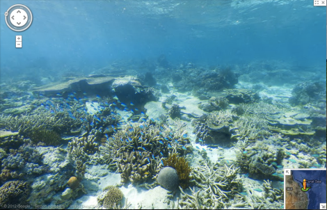
If you’ve used Google Maps at least once, you’re familiar with the “Streetview” feature. Imagine a street view underwater: Google has partnered with Catlin SeaView Survey to conduct a series of scientific expeditions and capture panoramic views of the underwater environment using a system of cameras.
Over 50,000 images have been collected and edited to create a continuous panorama, similar to Google Maps’ Streetview. The expedition covered the Great Barrier Reef in Australia, and other fronts will soon be explored.
Immersing Yourself in the Underwater World
This virtual dive takes you directly into the depths of the Great Barrier Reef, just like you can explore the surface with Google’s Street View. Now, it’s possible to immerse yourself and explore hundreds of kilometers of the reef and the Coral Sea.
The project’s creators claim that this initiative is crucial for raising public awareness about the underwater world. Climate change poses an imminent threat to ocean health. Monitoring coral reefs around the globe is vital, and Google Maps’ latest innovation might be a step towards mitigating the damage.
A New Era in Ocean Exploration
Google Maps has taken the first step in exploring the uncharted depths of our oceans. This technology has the potential to revolutionize our understanding of the ocean floor and its inhabitants. As we continue to explore and learn more about the underwater world, we may uncover new species, ecosystems, and even solutions to pressing environmental issues.
But how does this work? Let’s dive deeper into the details.
The Science Behind Underwater Street View
Google Maps’ Underwater Street View uses a combination of cameras and sensors to capture panoramic views of the ocean floor. The technology is based on the same principles as Google’s traditional Streetview, but with some key differences. Instead of using ground-level cameras, underwater cameras are used to capture images of the seafloor.
The images are then edited and stitched together to create a continuous panorama. This process requires specialized equipment and expertise, making it a challenging but rewarding project.
The Importance of Monitoring Coral Reefs
Coral reefs are some of the most biodiverse ecosystems on the planet, providing habitat for countless species of fish, invertebrates, and algae. However, coral reefs are facing unprecedented threats from climate change, overfishing, and pollution. Monitoring these ecosystems is crucial for understanding the impacts of human activity and developing effective conservation strategies.
The Impact of Climate Change on Coral Reefs
Climate change is having a profound impact on coral reefs worldwide. Rising sea temperatures are causing coral bleaching events, while ocean acidification and increased storm intensity are leading to habitat destruction. The consequences of these changes can be devastating for the millions of people who depend on coral reefs for their livelihoods.
The Role of Underwater Street View in Coral Reef Conservation
Google Maps’ Underwater Street View has the potential to play a crucial role in coral reef conservation efforts. By providing a detailed and accurate representation of coral reef ecosystems, this technology can help researchers and policymakers develop more effective conservation strategies.
For example, by mapping the distribution of coral reefs around the world, scientists can identify areas that are most vulnerable to climate change and pollution. This information can be used to inform policy decisions and prioritize conservation efforts in these areas.
The Potential for Underwater Street View to Support Marine Conservation Efforts
Underwater Street View has the potential to support a range of marine conservation efforts, including:
- Habitat restoration: By mapping coral reefs and other critical habitats, scientists can identify areas that need restoration and prioritize conservation efforts in these areas.
- Species monitoring: Underwater Street View can be used to monitor populations of endangered species and track changes in their distribution over time.
- Climate change research: The technology can help researchers understand the impacts of climate change on coral reefs and other marine ecosystems, informing policy decisions and conservation strategies.
Conclusion
Google Maps’ Underwater Street View is a game-changer in ocean exploration. By providing a new way to explore and visualize the ocean floor, this technology has the potential to raise public awareness about the importance of marine conservation. As we continue to learn more about the underwater world, we may uncover new insights into the ocean’s secrets and develop effective solutions to pressing environmental issues.
FAQs
- What is Google Maps’ Underwater Street View?
Google Maps’ Underwater Street View is a feature that allows users to explore the ocean floor using panoramic views captured by underwater cameras. - How does it work?
The technology uses a combination of cameras and sensors to capture images of the seafloor, which are then edited and stitched together to create a continuous panorama. - What is the purpose of this feature?
The primary goal of Underwater Street View is to raise public awareness about the importance of marine conservation and the need to protect coral reefs from human impacts. - Can I use Underwater Street View for research or educational purposes?
Yes, Google Maps provides access to Underwater Street View data and images for researchers, scientists, and educators who want to use this technology for their work. - Will Underwater Street View be available on all platforms?
Yes, Underwater Street View will be available on both web and mobile platforms, allowing users to explore the ocean floor from anywhere with an internet connection. - Can I contribute to the project or provide feedback?
Google Maps encourages users to share their experiences and suggestions for improving the feature. Users can also submit requests for new areas of the ocean to be explored using Underwater Street View. - What are the potential applications of Underwater Street View?
The technology has a range of potential applications, including marine conservation, research, education, and even tourism. - Will Underwater Street View help mitigate climate change impacts on coral reefs?
Yes, by providing a better understanding of coral reef ecosystems and their responses to climate change, Underwater Street View can help inform conservation strategies and policy decisions that address these impacts.
The Future of Ocean Exploration with Google Maps
Google Maps’ Underwater Street View is just the beginning of a new era in ocean exploration. As this technology continues to evolve and improve, we can expect to see even more innovative applications in marine conservation, research, education, and tourism.
In conclusion, Google Maps’ Underwater Street View has opened up a new frontier in ocean exploration, allowing us to explore and visualize the underwater world like never before. This technology has the potential to revolutionize our understanding of the ocean floor and its inhabitants, providing valuable insights into the impacts of climate change on coral reefs and other marine ecosystems.
As we continue to explore and learn more about the underwater world, we may uncover new species, ecosystems, and even solutions to pressing environmental issues. The future of ocean exploration with Google Maps is bright, and it’s an exciting time to be a part of this journey of discovery.