
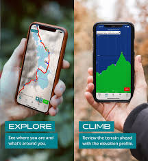
The technology is changing our way of enjoying sports and traveling, our hobbies and passions. If we don’t get caught up in nostalgic and vintage thoughts, we can discover really interesting things like the best apps for hiking in the mountains right now. They support us, provide information, suggest new itineraries, and sometimes even connect us with people who share our passion. Of course, they are also an important service for our safety.
Why Use These Apps?
There are two main reasons to refuse them. Let’s analyze them together to understand why we should overcome these obstacles.
We might want to disconnect from digital life, do a digital detox when going on a hike. In theory, it’s understandable desire but today, for safety and availability reasons, it’s better to have our smartphone with us in case of need and to be geolocated. So, already having one in our pocket, let’s use it for these apps. It’s clear that we reserve the right to not open chat, mail, and social media if what we want is a little relaxation and disconnection from this type of stimuli.
The second reason to not carry our phone could be related to fear of breaking or damaging it, but there are many protections and accessories that can reassure us.
What Are the Best Apps for Hiking in the Mountains?
The offer is always wider and spans various services, there’s something for everyone, whether you’re an experienced hiker or a beginner. One of the most appreciated service is certainly the ability to consult a map of the territory where we are, identifying our position on the map itself.
Oruxmaps is one of the most popular apps among hiking enthusiasts, so they can access a wide archive of maps, consulting them online or even downloading and using them offline when needed. It’s very technical with an essential and serious interface. It takes some minutes to learn how to use it but it’s practical and useful just like our fellow hikers like it. When you get a little comfortable with this app, you can also start registering your trail or georeferencing waypoints, even adding photos. It’s a free app that speaks Italian too.
Locus Map is similar and has nothing to lose in comparison. It has an extensive archive of maps and they are also downloadable for offline use. It’s demanding but effective to use it and it’s free. It speaks Italian but it’s only for Android.
GPS kit is finally an app for hikers who have a smartphone with an iOS system. On this app, we find various maps taken from Google, OpenStreetMap, NASA, and other reliable sites, we can also record tracks and mark waypoints with photos or without. To avoid loading too much material on the phone, you can select directly on the screen the area of the map that you really need to save for consultation offline, avoiding unnecessary parts to download.
Unfortunately, GPS kit is only available in English and not free at the moment.
Wikiloc is available for both Android and iOS and offers a service slightly different from the one described so far with other apps. This time there’s the advantage of being able to access a database of millions of trails and hikes thanks to the connection with a sharing site of tracks and descriptions of outdoor itineraries. There’s a free version but its functions are extremely limited and only few maps are available. You must necessarily pass to the paid package if you choose it. It’s at least in Italian and allows us to create and share our trails on social networks, enriching them with photos too. It gets closer to the social and aggregative side, it’s interesting for those who love sharing their passion and maybe finding new companions of hiking or “colleagues” to ask and give advice.
Viewranger is available for both iOS and Android as well and even if you stay in the free package you have many functions and maps at your disposal. It’s similar to Wikiloc because it allows us to share tracks of outdoor itineraries, with various information surrounding them that can help those who will follow our trails. If you pass to the paid version you also get detailed maps, but those free are already of good quality and downloadable. For those who love localizing themselves and looking around, there’s a fantastic option “Skyline” for recognizing nearby peaks through smartphone photography.
Weather
For those who love venturing into the heights it’s essential to know with precision the weather conditions in order to move equipped and with maximum safety. Even in this case, technology can help us with the best apps for hiking in the mountains related to weather.
Barometer Reborn is an app that measures atmospheric pressure and helps us understand the evolution of meteorological conditions when we’re on the go. It’s downloadable and usable only on phones with a clear pressure sensor. Unfortunately, it’s only in English but free, not banal to use but useful and practical.
For weather forecasts there are many apps but if we’re going into the mountains at a greater rate, we need the best one as Meteoblu, considered among the most reliable and clear. There aren’t frills but the information that we need for hiking in the mountains like temperature perception estimates and UV irradiance. It’s available for both iOS and Android, free and in Italian.
Safety
GeoResQ was developed in collaboration with the National Alpine and Speleological Rescue Corps (CNSAS) and is the best app for safety of hikers. It identifies our position and tracks our movements, it can send an alarm and coordinates geodetic to the Alpine Rescue Stations in case of difficulties. Unfortunately, it requires a phone signal connection to work.
It functions for devices Android, iOS and Windows and is free for CAI members, otherwise paid.
Conclusion
Hiking in the mountains with technology by our side has never been better. With these apps we can have fun while ensuring safety and minimizing risks of getting lost. Choose one that suits you best, try it out, explore its functionalities, set up your own trails, enjoy your hikes!
Frequently Asked Questions
-
Which app is the most popular among hikers?
Oruxmaps is one of the most popular apps among hiking enthusiasts. -
What is the difference between Wikiloc and Viewranger?
Wikiloc has a database of millions of tracks and trails, while Viewranger offers detailed maps and allows users to share their own tracks on social networks. -
Is Meteoblu only available for iOS or Android?
Meteoblu is available for both iOS and Android devices. -
Can I use GeoResQ without a phone signal connection?
GeoResQ requires a phone signal connection to work properly. -
Which app is the most reliable for weather forecasts?
Meteoblu is considered one of the most reliable apps for weather forecasts. -
Are all apps compatible with Windows devices?
No, not all apps are compatible with Windows devices. GeoResQ and Locus Map are compatible with Windows, while Viewranger and Oruxmaps require iOS or Android devices to work properly. -
How do I set up my own trails on Wikiloc?
To set up your own trails on Wikiloc, you need to create a free account on the platform, then use the “Create Trail” feature to upload your GPS data. -
Is it possible to share tracks on social media with Viewranger?
Yes, Viewranger allows users to share their tracks on social media platforms like Facebook and Twitter. -
Can I use Meteoblu for weather forecasts in the mountains?
Yes, Meteoblu provides detailed and accurate weather forecasts for mountainous areas. -
What is the difference between Oruxmaps and Locus Map?
Oruxmaps and Locus Map offer similar features, but Oruxmaps has a more user-friendly interface and supports offline maps. -
Is GeoResQ available in other languages besides Italian?
No, GeoResQ is only available in Italian. -
Can I use GPS kit for hiking on iOS devices?
Yes, GPS kit is compatible with iOS devices. -
What is the best app for tracking trails and hiking routes?
Oruxmaps, Locus Map, and Viewranger are all popular options for tracking trails and hiking routes. -
How do I download maps offline for use on Oruxmaps or Locus Map?
To download maps offline for use on Oruxmaps or Locus Map, you need to select the map you want to download and choose “Offline” as the download option. -
What is the difference between Meteoblu and other weather forecasting apps?
Meteoblu offers detailed and accurate weather forecasts specifically designed for mountainous areas, making it a popular choice among hikers and outdoor enthusiasts.
Additional Tips and Recommendations
- Always check the weather forecast before heading out on a hike.
- Bring a first aid kit and know how to use basic first aid techniques.
- Pack plenty of water and snacks, and bring a map and compass or GPS device.
- Let someone know your planned route and expected return time.
- Be aware of your surroundings and watch for potential hazards such as steep drop-offs, fast-moving water, and wildlife.
- Bring a repair kit with essentials like duct tape, safety pins, and a multi-tool.
Conclusion
Hiking in the mountains can be a challenging but rewarding experience. With the right tools and knowledge, you can stay safe and enjoy the beautiful scenery. By using one of the apps mentioned in this article, you can take your hiking to the next level and make the most of your time on the trails. Remember to always check the weather forecast, bring plenty of supplies, and be aware of your surroundings. With a little planning and preparation, you’ll be ready for an unforgettable adventure.
Final Thoughts
Hiking in the mountains is a great way to connect with nature and challenge yourself physically. By using technology to our advantage, we can make the most of our time on the trails and stay safe. Whether you’re a seasoned hiker or just starting out, there’s an app out there for you. Take some time to explore your options and find the one that works best for you. With the right tools and knowledge, you’ll be well on your way to creating unforgettable memories in the great outdoors.
Bonus Tips
- Always bring a paper map as a backup in case your GPS device or app fails.
- Use a compass to navigate when GPS is not available.
- Bring a whistle to signal for help if needed.
- Know how to use a satellite phone or two-way radio in emergency situations.
- Be prepared for changing weather conditions and know what to do in case of an avalanche.
By following these tips and using the right apps, you’ll be able to enjoy a safe and enjoyable hiking experience. Happy trails!


