
Introduction
The recent earthquake in central Italy has once again highlighted the need for innovative and effective seismic early warning systems. The Italian National Research Council (CNR) has been working tirelessly to develop and improve these systems, collaborating with several companies, including AlienData and TomTom. In this article, we will explore three groundbreaking tools developed by the CNR: Maplite, GeoSDI, and Eware.
Understanding Seismic Early Warning Systems
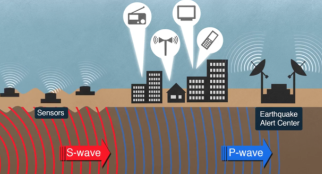
Seismic early warning systems are designed to detect seismic activity in real-time, providing critical minutes or even seconds before a significant earthquake strikes. These systems can significantly reduce damage and loss of life by alerting authorities and the public to evacuate the affected area. The CNR’s innovative tools have made it possible to create interactive maps that can help emergency responders navigate the disaster zone.
Maplite: A Mapping Revolution
MapLite is one of the three cutting-edge tools developed by the CNR. This system allows users to navigate an updated map in real-time, using their smartphone. MapLite enables users to share critical information about the situation, such as images and videos, on social media or via email. Recently, after a devastating earthquake, technicians were able to create interactive maps by integrating data from the Italian National Seismological Network (INGV) with pre- and post-earthquake aerial photographs.
MapLite’s development was made possible through collaboration between researchers at the CNR and engineers at AlienData. The system uses advanced algorithms to process seismic data in real-time, providing users with accurate information about the location, severity, and expected impact of an earthquake.
One of the key features of MapLite is its ability to provide users with real-time updates on the situation. This allows emergency responders to quickly assess the damage and make informed decisions about how to allocate resources. Additionally, MapLite’s interactive maps can be used to identify areas of high risk, allowing authorities to target their efforts and minimize the impact of the disaster.
GeoSDI: Harnessing the Power of Crowd-Sourced Data
GeoSDI is another revolutionary tool developed by the CNR. This app enables users with Android smartphones to become “points of reference,” providing critical information about the situation, including images and data with geographical coordinates. By leveraging crowd-sourced data, GeoSDI allows for more accurate mapping and better response times.
GeoSDI’s development was made possible through collaboration between researchers at the CNR and engineers at TomTom. The system uses advanced algorithms to process seismic data in real-time, providing users with accurate information about the location, severity, and expected impact of an earthquake.
One of the key features of GeoSDI is its ability to harness the power of crowd-sourced data. By encouraging individuals to share their experiences and observations during an earthquake, GeoSDI can provide a more comprehensive picture of the situation than traditional seismic monitoring systems. Additionally, GeoSDI’s interactive maps can be used to identify areas of high risk, allowing authorities to target their efforts and minimize the impact of the disaster.
Eware: A Multi-Risk Monitoring System
Eware is a console-based system designed to monitor multiple risks, including earthquakes, fires, and meteorological events. The CNR’s goal with Eware was to create a simple and accessible tool that could be used by everyone to receive early warnings about potential disasters. By combining data from NASA satellites, weather forecasts, and global seismic networks, Eware provides real-time information about the situation, enabling authorities to respond more effectively.
Eware’s development was made possible through collaboration between researchers at the CNR and engineers at several companies, including NASA and the European Space Agency. The system uses advanced algorithms to process data from various sources, providing users with accurate information about multiple risks.
One of the key features of Eware is its ability to monitor multiple risks simultaneously. By combining data from different sources, Eware can provide a comprehensive picture of the situation, allowing authorities to respond more effectively. Additionally, Eware’s console-based interface makes it easy for users to access and understand the information provided by the system.
Interoperability: The Key to Effective Emergency Response
One of the most significant strengths of these tools is their interoperability. This means that all stakeholders involved in emergency response can access and contribute to the mapping process, ensuring that the information is accurate and up-to-date.
Interoperability is critical for effective emergency response because it allows multiple agencies and organizations to share information and coordinate their efforts. By providing a common platform for data sharing and analysis, interoperable systems like MapLite, GeoSDI, and Eware can help reduce response times, improve decision-making, and ultimately save lives.
Benefits of Seismic Early Warning Systems
Seismic early warning systems offer several benefits, including:
- Reduced damage: By providing critical minutes or seconds before an earthquake strikes, seismic early warning systems can help minimize damage to infrastructure, buildings, and personal property.
- Improved response times: By alerting authorities and the public to evacuate the affected area, seismic early warning systems can improve response times and reduce the impact of a disaster.
- Increased safety: Seismic early warning systems can provide critical information about the location, severity, and expected impact of an earthquake, allowing individuals and communities to take necessary precautions to protect themselves.
- Enhanced preparedness: By providing real-time updates on seismic activity, seismic early warning systems can help communities prepare for earthquakes and other disasters, reducing the risk of injury or death.
Future Directions
The future of seismic early warning systems holds great promise, with ongoing research and development aimed at improving accuracy, reducing latency, and expanding coverage to include more regions. Some potential areas of focus include:
- Advancements in sensor technology: Developing more accurate and reliable sensors that can detect seismic activity in real-time.
- Improved data processing algorithms: Developing advanced algorithms that can process large amounts of data from various sources, providing users with accurate information about multiple risks.
- Increased public awareness: Educating the public about the benefits and limitations of seismic early warning systems, as well as how to use them effectively in emergency response situations.
Conclusion
The CNR’s innovative seismic early warning systems have revolutionized the way we respond to natural disasters. By leveraging cutting-edge technologies like Maplite, GeoSDI, and Eware, we can minimize damage and loss of life. These tools demonstrate the power of collaboration between research institutions, companies, and governments in creating effective solutions for emergency response.
As we look to the future, it is clear that seismic early warning systems will play an increasingly important role in reducing the impact of natural disasters around the world. By continuing to develop and improve these systems, we can create a safer and more resilient world for all.
FAQs
- What is a seismic early warning system?
A seismic early warning system is a network of sensors and software that detect seismic activity in real-time, providing critical minutes or seconds before a significant earthquake strikes.
2. How do Maplite, GeoSDI, and Eware work?
These tools use various technologies, including GPS, cameras, and satellite data, to create interactive maps that provide early warnings about potential disasters.
3. What is the purpose of crowd-sourced data in emergency response?
Crowd-sourced data can provide critical information about the situation, such as images and videos, which helps emergency responders navigate the disaster zone more effectively.
4. How does Eware monitor multiple risks?
Eware combines data from NASA satellites, weather forecasts, and global seismic networks to provide real-time information about potential disasters.
5. What is the importance of interoperability in emergency response?
Interoperability ensures that all stakeholders involved in emergency response can access and contribute to the mapping process, ensuring accurate and up-to-date information.
- How can these tools be used by individuals?
Individuals can use these tools to receive early warnings about potential disasters, allowing them to take necessary precautions to protect themselves and their loved ones.
7. What is the future of seismic early warning systems?
The future of seismic early warning systems holds great promise, with ongoing research and development aimed at improving accuracy, reducing latency, and expanding coverage to include more regions.
- How can governments and organizations collaborate to improve emergency response?
Governments and organizations can work together to develop and implement effective seismic early warning systems, sharing resources and expertise to create a safer and more resilient world.


