
Google’s mission to map every corner of the world continues to amaze us. From the depths of the ocean to the highest peaks, their efforts have made it possible for us to explore and discover new wonders. In this article, we’ll take you on a journey through one of the most iconic natural landmarks in the United States – the Grand Canyon – using Google Street View.
The Grand Canyon: A Monumental Wonder
Located in Arizona, USA, the Grand Canyon is an awe-inspiring sight that has been fascinating humans for centuries. This vast expanse of rugged terrain stretches over 277 miles long, up to 18 miles wide, and a mile deep. The Colorado River, which flows through the canyon, has carved out a path over millions of years, creating a breathtaking landscape of layered rock formations.
The Grand Canyon is not just an impressive sight; it’s also a significant cultural and historical landmark. Native American tribes have lived in the area for thousands of years, leaving behind artifacts and stories that provide valuable insights into the region’s rich history. The canyon itself has been shaped by geological forces, creating unique rock formations and vistas that have captivated visitors from around the world.
Google Street View: Mapping the Unmappable
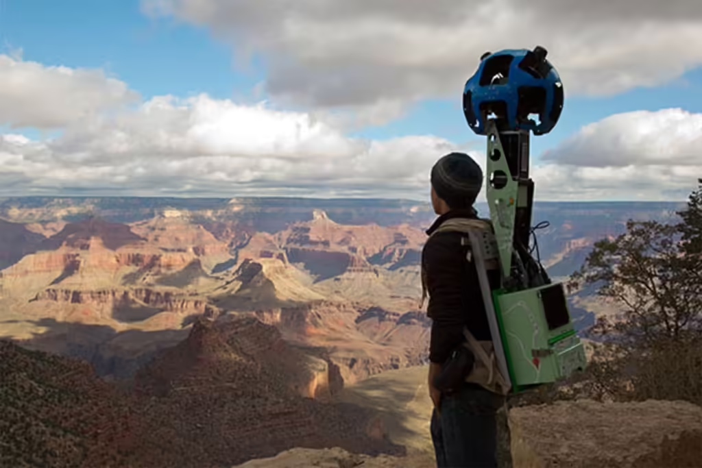
To capture the grandeur of the Grand Canyon, Google’s street view team employed a specialized device called Trekker. This high-tech backpack was designed to carry a heavy load of cameras and sensors that could map trails and roads in areas inaccessible by traditional auto Street View vehicles.
The Trekker is an impressive piece of engineering, weighing around 40 pounds (18 kilograms) and containing 15 sets of lenses for the camera. The device uses Android operating system and captures images every 2.5 seconds, providing detailed panoramic views of trails and roads inaccessible by traditional auto Street View vehicles.
The Weight of Exploration
Imagine carrying a backpack weighing 40 pounds on your back while trekking through the wilderness. That’s what Google’s operators had to do when using the Trekker device to capture images for Google Street View. This was no ordinary bag, but a custom-built, high-tech pack that held an impressive array of equipment.
To put this into perspective, consider the physical demands of hiking in the Grand Canyon. The terrain is rugged, with steep inclines and declines, making it essential for hikers to be well-prepared. The Trekker device represents a significant step forward in exploration technology, allowing Google to capture high-quality images in areas that would otherwise be inaccessible.
The Trekker: A Device Fit for Exploration
The Trekker is designed to map trails and roads where traditional auto Street View vehicles cannot access. This includes areas with dense vegetation, steep terrain, or narrow paths that are difficult to navigate by car or bike. The device is also equipped with sensors that detect obstacles and adjust the camera’s position accordingly.
With the Trekker, Google’s operators can capture stunning panoramic images of the Grand Canyon’s trails and roads. These images provide a unique perspective on the environment, allowing users to explore new areas and discover hidden features.
Beyond Roadmaps: Exploring the Grand Canyon
Google Street View has traditionally focused on mapping roads and highways. However, with the introduction of the Trekker device, they’re gradually pushing beyond this scope to explore other areas of interest. The Grand Canyon is a prime example – a place accessible only to hikers, yet now fully mapped by Google.
The Grand Canyon’s vast expanse and varied terrain make it an ideal candidate for mapping using the Trekker device. From the Colorado River to the canyon’s rim, every inch of this natural wonder can be explored through Google Street View.
The Importance of Panoramic Images
Google’s panoramic images are an essential part of their mapping efforts. These detailed views provide a unique perspective on the terrain, allowing users to explore and discover new aspects of the Grand Canyon. The Trekker device has enabled Google to capture images with remarkable detail, making it possible for us to experience this natural wonder in a way that was previously unimaginable.
Panoramic images are particularly useful for hikers and backpackers who want to plan their routes or identify potential hazards. By examining these images, users can gain a better understanding of the terrain and make informed decisions about their travel plans.
From Hikers to Citizens: Accessible Exploration
One of the most exciting aspects of Google Street View is its ability to make exploration accessible to everyone. Whether you’re a hiker or just curious about the world around you, Google’s panoramic images can transport you to new and exciting places. The Grand Canyon is an excellent example – now fully mapped, it invites us all to explore its vast expanse.
Google Street View has democratized exploration, providing a platform for users to access and share their own experiences and photos. This has led to a surge in user-generated content, with millions of users contributing to the platform’s ever-growing library of images.
Google’s Commitment to Mapping
As we continue to explore and discover new wonders through Google Street View, it’s essential to recognize the company’s commitment to mapping our world. From oceans to mountains, Google’s efforts have made it possible for us to experience the beauty of our planet like never before.
Google’s mission is not limited to mapping natural landmarks; they’re also working on projects that help protect and preserve our environment. For example, their Street View imagery has been used to track deforestation and habitat destruction, providing valuable insights into the impact of human activities on the natural world.
The Future of Exploration: Trends and Predictions
As technology advances, we can expect even more innovative applications of Google Street View. The future of exploration is bright, with emerging trends in augmented reality and virtual reality set to revolutionize the way we interact with maps and explore new environments.
One potential application of Google Street View is in the field of education. By providing immersive, interactive experiences of real-world locations, educators can create more engaging and effective learning materials for students.
Conclusion
Google Street View has taken us on an incredible journey through the Grand Canyon, one of the most iconic natural landmarks in the world. By using specialized devices like the Trekker, Google has enabled us to experience this breathtaking landscape in unprecedented detail. As we continue to push the boundaries of what’s possible with technology, we can’t wait to see where our next adventure takes us.
Frequently Asked Questions
Q: What is Google Street View?
A: Google Street View is a service that allows users to explore and discover new places through panoramic images captured by specialized devices like the Trekker.
Q: How does the Trekker work?
A: The Trekker device uses Android operating system and captures images every 2.5 seconds, providing detailed panoramic views of trails and roads inaccessible by traditional auto Street View vehicles.
Q: Why is Google mapping the Grand Canyon?
A: By mapping the Grand Canyon, Google aims to provide an accessible and immersive experience for users, allowing them to explore this natural wonder in unprecedented detail.
Q: What are the benefits of panoramic images?
A: Panoramic images enable users to explore new places and discover hidden aspects of the environment, making exploration more engaging and interactive.
Q: Can anyone use Google Street View?
A: Yes, Google Street View is accessible to everyone, regardless of age or ability. The platform provides a unique perspective on the world, allowing users to explore and discover new wonders.
Q: What’s next for Google Street View?
A: Emerging trends in augmented reality and virtual reality are set to revolutionize the way we interact with maps and explore new environments, taking Google Street View to new heights.
Q: How does Google ensure accuracy and quality of its images?
A: Google employs a rigorous quality control process to ensure that images captured by specialized devices like the Trekker meet high standards of accuracy and detail.
Q: Can I use Google Street View for commercial purposes?
A: Yes, business users can obtain a Google Street View API key to access premium features and integrate maps into their own applications.
Q: How do I get involved with Google Street View?
A: Users can participate in street view projects by joining local mapping initiatives or sharing their own experiences and photos through the Google Street View community.


