Cartography, the art and science of map-making, has been around for thousands of years. From ancient civilizations to modern times, cartographers have sought to represent the world on a flat surface, with varying degrees of accuracy and detail. In this article, we will delve into the history of cartography, explore its different forms, and discuss the key concepts that have shaped the field.
Understanding the Basics of Cartography
Cartography is an interdisciplinary field that combines geography, mathematics, and computer science to create accurate and informative maps. Cartographers use various techniques, such as geographic information systems (GIS), remote sensing, and spatial analysis, to gather data and analyze it for mapping purposes.
The process of creating a map involves several stages:
- Data collection: Gathering information about the area or region to be mapped.
- Data processing: Converting raw data into a format that can be used for mapping.
- Map design: Choosing a scale, projection, and other visual elements that will convey the information effectively.
- Map production: Creating the final map using computer software or traditional techniques.
The Evolution of Cartographic Representation
There are several ways to represent the Earth’s surface:
- Globes: The most accurate representation, globes are spherical in shape, just like our planet. However, they are often too small to provide useful information.
- Plastics: Also known as models or scale models, these representations are three-dimensional and can capture the details of a specific area. However, they are limited to a single location and cannot show relationships between different areas.
- Maps: Cartographic representations that approximate the Earth’s surface, maps offer a balance between accuracy and detail. They use various techniques to reduce the complexity of the globe, making them more manageable for everyday use.
Understanding Scales in Cartography
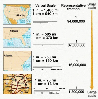
A scale is the ratio between distances on a map and those on the ground. It allows cartographers to create maps that are proportional to their actual size. The most common type of scale is the rectangular map, which uses a standard rectangular shape to display information. Another type, conformal mapping, preserves angles and shapes while reducing area.
Scales can be classified into different types based on their purpose:
- Large-scale maps: These maps are used for urban planning, surveying, and other applications where detailed information is necessary.
- Medium-scale maps: Used for navigation, tourism, and other purposes where a balance between accuracy and detail is required.
- Small-scale maps: These maps are used for general reference, such as atlases and globes.
Types of Maps
Maps can be categorized into several types based on their purpose and scale:
- Mappamondi (Planisferes): These maps show the entire Earth’s surface, highlighting its essential features. They often have very small scales.
- Carte Generali: Representing major regions like countries or continents, these maps emphasize key characteristics. Their scales are moderate to large.
- Carte Corografiche: Focusing on specific areas, these maps highlight the region’s distinctive features. Scales vary from medium to large.
The Importance of Cartography in Modern Times
Despite advancements in technology, cartography remains a vital tool for understanding our world. From:
- Navigation and transportation to scientific research and urban planning, accurate maps are essential.
- Digital mapping: The rise of online platforms has transformed the way we create and share maps.
The Power of Atlases
An atlas is a collection of maps that represent different regions or areas of interest. These comprehensive resources provide valuable insights into the world’s geography, history, and culture. Atlases are often used in educational settings to teach students about different parts of the world and their features.
Advances in Cartographic Technology
The development of new technologies has significantly impacted the field of cartography:
- GPS: Global Positioning System technology allows for precise location tracking and navigation.
- GIS: Geographic Information Systems enable the analysis of spatial data and the creation of detailed maps.
- Remote sensing: Satellite and aerial imagery provide high-resolution images of the Earth’s surface, facilitating map creation and analysis.
Challenges in Cartography
Despite the progress made in cartography, there are still several challenges that need to be addressed:
- Data accuracy: Ensuring that data is accurate and up-to-date is crucial for creating reliable maps.
- Map maintenance: Updating maps regularly to reflect changes in the environment and society is essential.
- Accessibility: Making maps accessible to a wider audience, particularly those with disabilities, is an ongoing challenge.
Conclusion
Cartography has come a long way since ancient civilizations first began representing the world on a flat surface. From globes to digital maps, cartographers have continued to push the boundaries of what is possible. As technology advances and new challenges arise, it is clear that cartography will remain a vital tool for understanding our world.